BUT the observed sea level rise since 1969 was just 82.8mm (1.8mm/year), ~ 2% of his prediction.
The Portland Maine (USA) Tide Gauge shows –
- Sea level has risen at a rate of 1.8 ± 0.1 mm/yr (or 0.6 feet per century) for the last 94 years.
- 1977 was higher than 1988.
- Sea-Level in the Gulf of Maine in 2005 was 3mm higher than today.
- Going back to 1947, Sea-Level in the Gulf of Maine was identical to 2002.
http://www.maine.gov/dacf/mgs/explore/marine/sites/mar07.pdf
Bangladesh has long been a poster-child for sea level rise & climate change refuges
Headlines like –
‘Bangladesh slipping into the sea’
‘50 million Bangladeshis would flee the country by 2050 if sea levels rose’
‘Seas in Bangladesh could rise as much as 13 feet by 2100, four times the global average’ (just take a moment to think out the logic behind that statement, [“four times the global average”] is this ‘new physics’ where seawater DOESN’T find its own level ?… or is there something else going on, like water staying still & the land sinking, due to water abstraction )
( Global average sea level rise is ~170 mm/century, but in Bangladesh there is an apparent rise of ~ 330mm/century ) see http://www.sealevel.info/MSL_graph.php?id=510-003
‘Bay of Bengal’s vanishing islands’
But when you look into it, surprisingly, Bangladesh is actually gaining more land area than its losing.
http://www.sciencedirect.com/science/article/pii/S221209631300003X
Bangladesh’s main problems are not climate, they starts with the lasting legacy of the British Partition of India in 1947 (look to your history books), it’s population is growing faster than the land is accruing & forests are being cut in the foothills, increasing flooding from the monsoons.
March 29, 2001, CNN: “In ten year’s time, most of the low-lying atolls surrounding Tuvalu’s nine islands in the South Pacific Ocean will be submerged under water as global warming rises sea levels.”
But by 2015 the Atolls were almost unaltered, the observed sea level rise since 2001 = 4.2mm, although the island IS sinking at a greater rate see http://www.legos.obs-mip.fr/members/delcroix/publis-pdf/Becker_etal_GPC12.pdf?lang=en
[Using GPS precise positioning, these authors clearly demonstrate that during the past ~two decades, earthquake-related vertical land motion led to large subsidence (of about – 10mm/yr). Also the coral base of the atoll was dug up & used as fill to create the airport runway, producing instability.]
“There is presently no evidence that these islands are going to sink,” Virginie Duvat – University of La Rochelle. 2015
Nearby Kiribati’s (Pacific) Monthly tide gauge data – Graphed. –
Shows a 14mm rise in 38 years = 0.3mm/yr = 36.8mm (1½ inch)/ century
https://drive.google.com/file/d/0B2mJHy077e-vYnNVLXQtZ2RnM0k/view?usp=sharing
Actual sea level rise
1985 Al Gore predicted 2.2m (7ft ) rise by 2100 (18mm/yr)
By 2006 Al Gore had upped it to 4 to 6 meters (13 to 20 ft) for his film. (that’s 64mm/year !!!)
2007 James Hansen (NASA), assumed a sea-level rise of 5 m this century (53mm/yr)
The IPCC (2013) nearly 1m by 2100 (11mm/yr)
A 2015 study by sea level rise ‘experts’ concluded a range between 0.2 – 2 m (8 inch – 6.6 feet) (2.5 – 23mm/yr)
Quite a choice, 2.5 to 64mm/yr …so who do you believe ?? …
…try NOAA (National Oceanic and Atmospheric Administration).
Absolute measured global sea level rise is just 1.7-1.8 **millimeters/year. ~ 180mm (7inch)/ century.
https://web.archive.org/web/20150910050658/http://www.tidesandcurrents.noaa.gov/sltrends/globalregional.htm 10/9/15 Had to use the waybackmachine because NOAA just made it disappear in mid Sept, ahead of COP 21 & replaced it with http://climate.nasa.gov/vital-signs/sea-level/ inaccurate satellite data that doesn’t match the tide gauges,
See – https://stevengoddard.wordpress.com/2015/12/06/nasa-sea-level-fraud/ & Data Tampering
**Corroborated by & more reliable (as they don’t ‘adjust’ historical data) here – http://onlinelibrary.wiley.com/doi/10.1029/2006GL028492/abstract
More at – http://wattsupwiththat.com/2012/05/16/is-sea-level-rise-accelerating/
Table 10.7 from the IPCC’s AR4 report – https://www.ipcc.ch/publications_and_data/ar4/wg1/en/ch10s10-6-5.html – tells us that in ALL scenarios Antarctica contributes negatively to sea level rise, because of increased snow & ice formation.
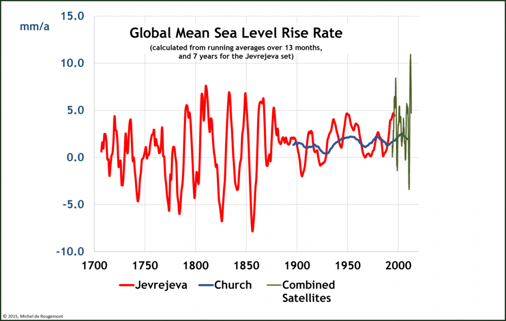
 Source: John A. Church, Neil J. White, “Sea-Level Rise from the Late 19th to the Early 21st Century”, Surveys in Geophysics, Volume 32, Issue 4-5 , pp 585-602
and Jevrejeva, S., J. C. Moore, A. Grinsted, and P. L. Woodworth, “Recent global sea level acceleration started over 200 years ago?” (2008), Geophys. Res. Lett., 35
Satellites : Combined TOPEX/Poseidon, Jason-1 and Jason-2/OSTM
The coefficient of correlation R2 for the Jevrejeva series is 0.0555, which indicates that nothing is statistically significant to determine an acceleration of the rate of rise over a long period of time.
Data from 1,269 tide stations (some go back to 1811) http://www.sealevel.info/data.psp