Linear Relative Mean Sea Level (MSL) trends in mm/year and in ft/century
http://tidesandcurrents.noaa.gov/sltrends/mslGlobalTrendsTable.htm 200 + local tide station results.
Sea level recording
The Global Sea Level Observing System (GLOSS) – http://www.gloss-sealevel.org/
UK – The National Tidal and Sea Level Facility – http://www.ntslf.org/data/uk-network-real-time
Sea level trends since 1900. http://www.psmsl.org/products/trends/
Global Tide Gauge Data here – http://www.psmsl.org/data/obtaining/
For a host of technical reasons, satellites (TOPEX/Poseidon & Jason) are NOT capable of giving accurate sea level data (its only accurate to ±25mm), Tide Gauge Data is accurate to ±3mm. http://etracinc.com/products/tidetrac/
Explanation of tide measurement problems – Start at 15min https://www.youtube.com/watch?v=1gmW9GEUYvA
• The Great Barrier Reef complex is maybe 18 million years old but the current reef is only around 8,000 years old, built on a platform of older reefs.
Around Australia and world wide the sea level 18,000 years ago was about 150m lower than today. It reached approximately modern levels around 6,000 years ago ( ~ 12mm rise/year)
For a real bit of sea level rise; the sea rose 16m in the 300 years between 14,600 and 14,300 years ago……that’s a ~ 53mm (2 inch) /year. – https://research.jcu.edu.au/tropwater/resources/ – Who/what do you think caused that ??… Clue, Not CO2.
BUT- Have sea-levels really been rising remorselessly over the centuries?? By almost 280mm per century, as that graph above would suggest ?? Yes & No !!
Historical records
The ancient port at Phaselis (founded in 690 BC ) is 6m under water, giving a sea-level rise of ~ 23mm per century.
The Roman 1st century BC harbour at Ephesus is ~5m above where it should be. suggesting a ~25mm per century sea-level fall.
The ancient harbour at Caesaria (20BC) is just under the present sea-level,
The port Heracleion near Alexandria is 10m or so below where it should be, and that may be due to its being built on alluvial sand.
and that may be due to erosion.
Rome’s principal 1st century A.D. maritime harbor, ‘Portus’ is now 2miles inland.
Nothing is as clear cut as it originally appears.
Here are a few good, long-term records:
- Australia: http://sealevel.info/680-140_Sydney_uncropped_2014_1p5ar.png
- Germany: http://sealevel.info/120-022_Wismar_2015-4e2_sq_75pct.jpg
- San Diego: http://sealevel.info/9410170_San_Diego_uncropped_2014_1p5ar.png
- Hampshire UK: a tidal grain mill that has been using the tide for 900 years in the same spot! Eling Tide Mill
- Look at this tapestry of Traitors Gate Tower of London circa 1150AD

- Here’s what it looks like today –

No dramatic sea level rise in 865 yrs.
- Harlech Castle built 1289, the west entrance was a Watergate, just where the road & rail cross in this picture –

- http://www.harlech.com/ – the sea is now approx 1 mile away to the left.
- Pevensey Castle built in 290AD was a Roman Fort. The sea surrounded it on three sides, now it is 1.5km from the sea.
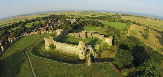 https://en.wikipedia.org/wiki/Pevensey_Castle
If you know how to read a graph, it should be obvious to you that there’s been no acceleration in the rate of sea-level rise in response to anthropogenic CO2.
Here is a link to a list of at least THIRTY peer review journal papers establishing the lack of sea level rise acceleration/increase – http://sealevel.info/papers.html
More implausible sea level rise claims
http://wattsupwiththat.com/2015/08/28/on-nasas-recent-sea-level-claim-science-isnt-broken-except-when-it-is/
Coral Atolls are created by sea level rise, not destroyed by sea level rise…as discovered 150 years ago by Charles Darwin – http://darwin-online.org.uk/EditorialIntroductions/Chancellor_CoralReefs.html
Is any demise of the world’s coral atoll islands due to man-made CO2-caused sea level rise, or is it man killing off the parrotfish?? Clear explanation of the mechanism by Willis Eschenbach